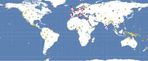
The World Atlas of Language Structures maps data from typological studies to a world map. In addition to the online version, there is also a program for the local production of maps.

However, the options for customisation are limited. I use the free and open command-line tool GMT for the production of linguistic maps. It has awesome tools for all kinds of tasks, including the mapping of symbols from a file of coordinates. Here is a quick guide on how to produce your own pretty WALS map.
- Download your data set from WALS in tab-separated values (there is a button just underneath the header). Save it as walsXY.xy, where XY is the WALS feature you want to map.
- Remove the metadata lines at the top of the file and the header of the table.
- GMT does not distinguish between tabs and other simple blanks. Replace all simple space characters by nothing or a character of your choice.
- Start GMT and move to the directory to which you have downloaded your data set and where you want to produce your map.
- In the same folder, create a cpt file containing the colors that you want to assign to different values. My wals.cpt file has the following content: (number of WALS value, RGB values).
1 240/11/0
2 0/210/240
3 240/180/0
4 28/142/59
5 28/54/142
6 90/28/142
7 211/211/170
8 0/0/0
- Run the following commands in GMT:
pscoast -R-180/180/-70/80 -JQ7i -K -Ssteelblue > walsXY.ps
psxy walsXY.xy -R -i5,4,2 -J -O -Sc0.15c -Cwals.cpt >> walsXY.ps
- For more options, see the documentation of GMT.